Read the current application and agency requests before relying on historical or advocacy material.
Campaign position, not an agency finding. Read the current filing, the withdrawn designs, the County consultations, and the campaign’s formal resident correspondence; as of September 16, the public viewer still listed the application as Incomplete and showed no completeness determination or permit approval. On October 9, SWFWMD General Counsel separately confirmed that the application remained under review. See the design-history comparison.
The correspondence and community-notice library was updated . Permit status and the two docketed resident-letter records were last verified September 16; later records are labeled by their transmission, acknowledgment, and publication status.
Older research records retain their own access dates. Recheck time-sensitive links after seven days; the official permit record can change.
Publication boundary: The owner authorized publication of the campaign archive on September 2, 2026. We now provide stable copies of selected agency records, applicant filings, resident advocacy, historical materials, and privacy-reviewed website editions. Each item is labeled by who created it and what it can prove. Protected originals, private submissions, signatures, shipping identifiers, sensitive medical details, and third-party contact information remain outside the public site unless the person concerned has independently authorized publication.
What’s at Stake is a campaign narrative page, not an authoritative source.
Use it to understand the campaign position, then follow its links back to the official and historical records on this source shelf.
Community notices and agency acknowledgments
Petition-readiness newsletter and October 9 District response
Community newsletters are campaign communications, not formal Chapter 120 petitions. Agency acknowledgments establish only what the agency actually confirmed.
Formal permit challenge: sign up now for official SWFWMD notice
The newsletter explains the expected short Chapter 120 challenge window, how residents can request official agency-action notice, the difference between notice requests and legal petition filing, and what original evidence residents should preserve now.
Archive status: the web page preserves the exact wording sent to Save Tarpon Woods alert subscribers. It also labels later or separate October 9 information so that the historical newsletter is not silently rewritten.
General Counsel Christopher A. Tumminia confirmed that the District received and reviewed the October 8 emergency notice and prior Save Tarpon Woods submissions and placed them in Application 930235’s file of record. He stated that the application remains under review and that any agency action will include notice of Chapter 120 rights.
Scope of acknowledgment: it is not agency action and does not decide the permit. It did not state whether the District performed the requested field inspection, issued event-specific preservation instructions beyond ordinary records retention, or required additional hydraulic analysis.
Contact-list status: as displayed October 9, the WMIS application contact screen lists Save Tarpon Woods, attention William R. Nobles, with admin@SaveTarponWoods.com and “Permit Mail Method: Email.” That strongly supports email-contact status for this application. Because the separate statutory-notice consequences are significant, Save Tarpon Woods is still seeking written confirmation that its section 120.60(3) request is recorded. The full screenshot is not republished because it displays unrelated third-party contact details.
Formal resident correspondence
Every letter is published separately, in full
Start with the October 8 emergency flood notice, then read the September 23 second supplement, September 16 consolidated follow-up, September 2 supplemental demand, and August 27 technical challenge as separate records. Sending a letter establishes the campaign’s transmission; it does not establish docketing, agency agreement, or agency action unless the card says that status was separately verified.
Actual Brooker Creek overbank conditions and demand for watershed-scale hydraulic review
Author: William R. Nobles, Jr. · Application: 930235 / Permit 47575.002 · Related records: 889588 / 47575.000 and 907654 / 47575.001.
The letter reports a personal observation of Brooker Creek outside its normal channel along the eastern boundary of the author’s Annwood Road property and preserves provisional USGS readings from the same rain event. At 2:00 p.m., station 02307359 reported a gage height of 11.88 feet and discharge of 253 cubic feet per second—0.12 foot, about 1.44 inches, below the 12.0-foot roadway-flooding level cited in that morning’s Alert Pinellas warning.
The notice requests preservation of gauge, rainfall, high-water, road, drainage, maintenance, and agency-communication records; prompt field inspection; signed-and-sealed existing- and proposed-condition modeling of the hydraulically connected Brooker Creek system; vertical-datum reconciliation; floodway no-rise and compensatory-storage review; construction, planting, maintenance, failure, and abandonment scenarios; drainage-easement and conveyance-capacity analysis; and independent applicant-funded peer review with public access to native files.
Receipt and evidence status: emailed October 8 to the listed government, elected, and media recipients; a community newsletter was also sent. On October 9, SWFWMD General Counsel confirmed District receipt, review, and placement in Application 930235’s file of record. That acknowledgment does not establish agreement, technical action, permit action, or receipt by every other addressee. The event does not prove an unbuilt project caused flooding. It documents flood-sensitive existing conditions and supplies potentially important calibration data. USGS marks the readings provisional; gage height is not creek depth, and the letter explains why vertical datums must be reconciled before comparing the reading with survey or FEMA elevations.
Challenge to the September 18 and September 21 submissions
Author: William R. Nobles, Jr. · Application: 930235 / Permit 47575.002 · Related records: 889588 / 47575.000 and 907654 / 47575.001.
This formal supplement—not a replacement for the August 27, September 2, and September 16 submissions—examines proposed legal instruments filed on September 18 and 21, including the proposed access easement, Crossroads ownership affidavit, Ridgemoor sewer notice, parcel descriptions, and whether those documents actually satisfied any part of SWFWMD’s December 14, 2025 Request for Additional Information.
The letter asks SWFWMD to keep the application formally incomplete, publish an item-by-item RAI status matrix, explain how it classifies the post-September 14 submissions, require corrected title and survey records, dependable access, perpetual water-source evidence, and resolve the remaining hydrology, floodway, drainage, wetland-credit, soil, wildlife, cost, and financial-assurance issues before any material agency action.
Evidence limits: the letter recognizes that a requested draft need not already be executed or recorded, but argues a draft cannot prove present legal rights. It treats metadata and facial legal-description issues as review indicators—not proof of fraud or failed title. The website does not represent this letter as docketed or adopted unless that status is separately verified.
Application remains incomplete; every outstanding deficiency must be answered
Author: William R. Nobles, Jr. · Application: 930235 / Permit 47575.002 · Related records: 889588 / 47575.000 and 907654 / 47575.001.
This comprehensive follow-up restates all seventeen unresolved categories, requests a written status matrix and point-by-point response, renews the records-preservation request, and makes clear that ownership is only one of the remaining deficiencies. It does not replace or narrow either earlier letter.
Publication status: this is a public web edition of the email sent September 16. As of publication, Save Tarpon Woods had not verified a corresponding new entry in SWFWMD's public docket. Sending proves transmission, not agency receipt, adoption, or action.
Deadline, three-application, survey, floodway, and oversight supplement
Author: William R. Nobles, Jr. · Application: 930235 / Permit 47575.002 · Related records: 889588 / 47575.000 and 907654 / 47575.001.
The letter, dated September 1 and transmitted September 2, preserves the August 27 objections and adds the exact extension chronology, a demand for neutral procedural review, the recovered intervening application, County consultation records, survey and title questions, floodway and modeling requirements, environmental-history analysis, fee accounting, and preservation of communications across all three records.
Official-file status: SWFWMD's September 2 email record contains the transmittal, the August 27 challenge, and this supplemental demand. The website PDF is byte-for-byte identical to the supplemental letter pages in that agency record. Filing proves receipt; it is not an agency finding or decision.
Author: William R. Nobles, Jr. · Application: 930235 / Permit 47575.002 · Type: resident advocacy and technical comment.
A detailed request that SWFWMD investigate unresolved acreage, wetlands, floodway, hydrology, wildlife, soil testing, planting, belowground ecology, title, default, financial assurance, and project-delivery issues before approval or credit release. It remains advocacy, not an agency finding.
These records document what the applicant submitted and what the agencies requested. Applicant assertions do not become agency findings merely because they appear in a permit file.
Surveyor: Johnson Surveying & Mapping · Displayed field date: February 27, 2025 · Drawing date: March 3, 2025 · Checked: March 17, 2025 · Revision: May 13, 2026.
The survey is certified to Avalon Building Corporation of Tampa Bay, Bryan J. Stanley, P.A., and Chicago Title; includes Parcel 1 and Parcel 3; reports 172.46 acres; says Parcel 2, an easement estate, was removed at the client’s request; and lists multiple Schedule B-II entries as “Intentionally Deleted.” Sheet 9 depicts topography adjoining numbered residential lots, including Lots 53 and 54.
Important limitation: the survey is evidence of what its signed drawing depicts—not an agency acceptance of the project boundary, credit areas, floodway, conservation easement, security plan, or title status. “Intentionally Deleted” is not proof of wrongdoing. Florida Division of Corporations records list Avalon Building Corporation of Tampa Bay inactive following a voluntary dissolution filed December 18, 2024; that fact alone does not determine the survey’s validity. Figure 14 in the RAI response is a separate schematic security map. The applicant should supply the title-version crosswalk, field and elevation methods, revision history, and one signed-and-sealed composite reconciling all relevant boundaries and work areas.
Issuing body: SWFWMD · Type: public permit record · Status: as last verified September 16, the viewer still listed the application as Incomplete and had not shown a completeness determination or permit approval.
Use for the current document list and application status. It is separate from withdrawn Applications 889588 and 907654.
Issuing body: SWFWMD public permit viewer · Type: withdrawn individual mitigation-bank record · Retrieved archive: all 102 documents publicly listed in the viewer at retrieval.
This withdrawn design proposed substantial excavation, pond and ditch filling, wetland creation, material export, and a stated total of 79.57 potential credits. The displayed 13.86- and 65.72-credit components sum to 79.58; the one-hundredth difference may reflect rounding and should be reconciled. Those were proposals, not approvals, and must not be represented as the current design or SWFWMD’s complete internal file.
Released here: 200 resident-photo derivatives, 13 supporting-image derivatives, five privacy-reviewed PDF editions, and stable local copies of key public records.
These are not all the same kind of evidence. An agency document shows what an agency recorded or decided. An applicant filing shows what the applicant submitted. A resident filing proves the agency received that resident’s statements, not that the agency adopted them. A campaign packet explains the opposition’s position. A historical document supplies context that must be tested against the current design.
The complete substantive filing is available with a one-page source note. Direct resident contact and shipping-label identifiers are obscured; the historic-map exhibits, Target 6 materials, source leads, and permit objections remain visible. The product images do not prove use at Tarpon Woods, contamination, or the current status of any inquiry.
This historical presentation explains how residents first organized around flooding, wildlife, green space, and public process. Four pages containing volunteer/family biographies or stale payment and address information are replaced with disclosure pages; the remaining slides are unchanged.
The packet preserves the opposition’s early flood, wildlife, public-record, media, and neighborhood concerns. Pages containing sensitive medical information, a personal profile, a face without documented consent, or reproduced third-party articles are replaced and explained. The packet is advocacy, not a County report or finding.
An industry professional discusses golf-course conditions and management issues. The substantive letter, author, title, company, and general office information remain visible; a signature and direct personal contact details are obscured. Treat it as expert correspondence, not an agency inspection or adjudication.
Community listening notes · privacy-reviewed edition
Pinellas DRC meeting notes
These approximate, timestamped community notes preserve residents’ account of a County Development Review Committee meeting. They contain paraphrase and commentary, are not a County transcript, and must not be used as exact quotations without checking the source video. One unattributed campaign inference is removed; the remainder is published as historical advocacy for comparison with County records.
Community letter concerning withdrawn Application 889588
This resident letter records the opposition’s early concerns and requests to SWFWMD officials. It is historical advocacy, not an agency finding, and later applications and records supersede portions of its context. Any reference to a DRC “transcript” should be read as a reference to community-prepared listening notes—not a certified County transcript.
The 398-page County/SWFWMD study package documents the watershed model, historic flooding, alternatives, Tarpon Woods coordination, constraints, and rejected concepts. It proves the agencies possess a substantial technical history; it does not model the present mitigation-bank design.
This agency-file package includes historic drainage materials and the 1847, 1944, and 1970 map exhibits at PDF pages 65–67. Filing establishes their presence in the record; it does not make later handwritten annotations an agency conclusion or a modern wetland delineation.
Read the original applicant package, the applicant’s RAI response, SWFWMD’s clarification request, and the FDEP submerged-lands worksheet. The first application was withdrawn; its design is evidence of proposal history, not the current plan. A blank campaign petition form is provided only as a historical template; it is not proof of submission, signatures, or supporter count.
Land-use, project-overview, site-plan, and operational records
The 2009 “320 units” letter concerns Ridgemoor Tract 8 and the original roughly 59.20-acre request—not present approval for 320 homes across the current 172-plus-acre proposal. The 2024 County overview is a dated project snapshot. The applicant master plan and authorization form answer different questions and should not be blended. The food-service inspection history is operational context only—not proof of environmental noncompliance, current site conditions, current-owner conduct, or the pending permit’s merits.
These images make selected record excerpts visible at a glance. Each is a metadata-free derivative; the complete underlying record and current official source control.
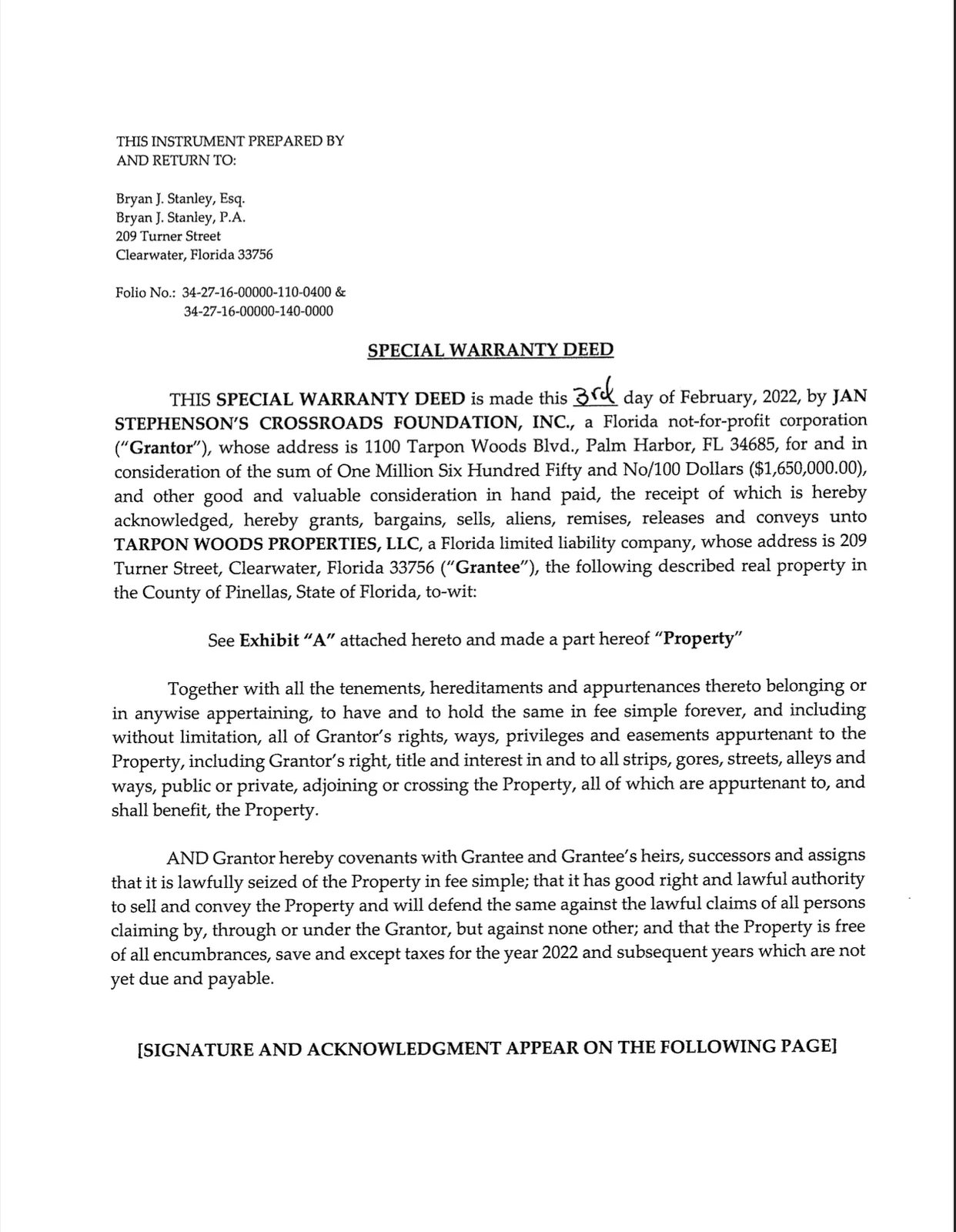
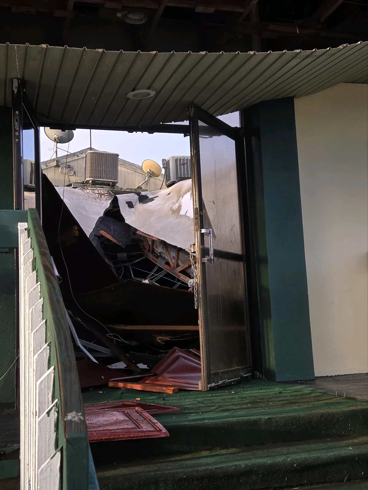
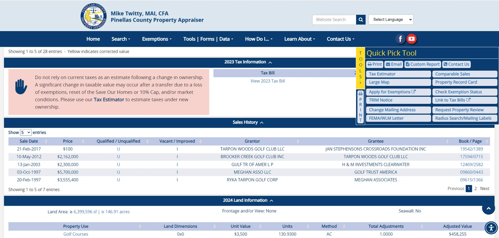
Special warranty deed, page-one excerpt. A Pinellas County Clerk public-record excerpt. It is not a complete title report, legal opinion, or proof that no later instrument exists. The signature/notary page is not republished.Historical SWFWMD cover page. This is a 2020 form excerpt from an earlier record—not the pending application and not evidence of agency approval.Structure-condition photograph. Owner-authorized archive image. Capture date, cause, responsibility, and present condition have not been independently verified.Sales-history snapshot. Point-in-time Property Appraiser excerpt. It is not proof of motive, current value, current ownership, or a complete title chain.
Why some website copies contain disclosed redactions: A document appearing on a government portal does not eliminate every third party’s privacy, safety, signature, or copyright interest. Redactions do not hide the permit arguments; they keep this campaign from needlessly redistributing direct contact data, health details, shipping identifiers, signatures, or complete copyrighted articles. William R. Nobles, Jr.’s own filed letters remain public as authorized by their author.
How to cite this archive
Identify the document’s creator, date, application or record number, and page. If an official agency link is available, cite that official record first and use our local copy for stable access. Say “the applicant stated,” “the resident alleged,” or “the agency requested” instead of flattening every source into fact.
Need a source not shown?
Use the permit record’s document list or submit a source lead. Do not upload personal data, private submissions, or copyrighted material you are not authorized to share.
Filters enhance the static list. With JavaScript disabled, every record remains visible.
Pinellas County Official Records · Instrument 2019338177
County waiver and release — limited to a 3.40-acre Exhibit A tract
Custodian: Pinellas County Clerk of the Circuit Court and Comptroller · Book/page: OR 20738/2541.
What the recorded instrument says: Pinellas County released specified management, maintenance, and treated-effluent-disposal rights only as to the 3.40-acre tract described in Exhibit A. It expressly says the waiver applies to that tract and not to the remainder of the Golf Course Property, and that the agreement remains effective on the balance, including continued acceptance of treated effluent.
The metes-and-bounds courses in Exhibit A also appear in Application 930235 title material as Parcel 3 (Fee Estate). That matching description is relevant to the current parcel, survey, utility, and easement reconciliation.
Important limitation: the instrument does not release the stated rights over the entire golf-course property. Matching description courses are not a title opinion, do not establish present ownership, and do not prove whether a later recorded instrument changed any right. The current title chain and complete governing agreement still control.
Pinellas County Property Appraiser · current parcel pages
Both Tarpon Woods tax parcels — current assessor indexing
Folio 34-27-16-00000-140-0000: indexed to TARPON WOODS PROPERTIES LLC · Folio 34-27-16-00000-110-0400: indexed to TARPON WOODS PROPERTIES LLC.
Displayed deed field: both pages show AAAAA/AAAA for “Last Recorded Deed / Book-Page,” rather than a Clerk instrument number and official-record book/page.
Important limitation: Property Appraiser indexing is useful assessment evidence, not a Clerk deed citation, title opinion, surveyed boundary, or proof of authority to encumber each acre. The ownership display must be reconciled with the recorded instrument, current title commitment, survey, and conservation-easement documents.
East of Tarpon Woods Boulevard — historical development and mitigation plans
Official index label: “EAST OF TARPON WOODS BLVD.” The scanned plans use the names Tarpon Woods Estates I, Ridgewood, and Woodridge Lakes and document development and mitigation planning in the broader Tarpon Woods area east of the boulevard.
Important limitations: our review did not locate either current golf-course folio—34-27-16-00000-140-0000 or 34-27-16-00000-110-0400—on the reviewed sheets. The plans identify different historical project names and parties. They are adjacent-area context, not proof of work on the present golf-course parcels, current ownership, current applicant conduct, a present wetland line, or a current mitigation-bank condition.
Bridlewood at Tarpon Woods — 1987 wetland-fill permit and later mitigation monitoring
What the file identifies: FDEP permit 521272533 was issued May 29, 1987 and expired May 29, 1992 for 0.75 acre of wetland fill at “Bridlewood at Tarpon Woods.” The record names First Florida International as permittee, gives 800 Tarpon Woods Boulevard as its address, and required 1.46 acres of forested-wetland mitigation.
What the 1995 record reports: an August 3 FDEP memo says an inspection found less than half of the required mitigation area had been created and much of the created area was herbaceous. The file discusses an earlier warning and permit transfers; a separate memo states that Parkwood performed the development.
Important limitations: this historical record concerns a different project, permittee, and development history. It does not establish a defect on either current golf-course folio, misconduct by the current applicant, failure of the present mitigation-bank proposal, or current ecological conditions. The 1995 observations must not be projected onto today's property without current mapping and field evidence.
FDEP current tank registry and historical agency file
Facility 8624510 — current tank-account status and the separate 1990–1991 record
Current registry: FDEP's DOPPLER cover report, run September 1, 2026 from data refreshed August 31, identifies “TARPON WOODS GOLF & TENNIS CLUB,” 1100 Tarpon Woods Boulevard, as a fuel-user/non-retail facility with status “OPEN.” It lists two 550-gallon aboveground tanks—vehicular diesel and unleaded gasoline—as “In Service,” plus three tanks as removed from the site. The current summary states “No Compliance Activity Data Found,” “No Open AOCs Found,” “No Open Violations Found,” “No Discharges Found,” and “No Property Owner Information Found.” “OPEN” is the storage-tank facility/account status, not an open contamination or enforcement case, and the report is not title evidence.
Historical file: an August 28, 1990 notification reports a diesel discharge discovered August 27 and detection through soil analysis/OVA-FID. A closure-report package received March 25, 1991 describes removal of a 2,000-gallon gasoline underground tank and a 3,000-gallon diesel underground tank, excavation of approximately 80 cubic yards of soil with elevated field-vapor readings at the diesel pit, laboratory soil results below detection limits, a gasoline-pit groundwater sample slightly above the then-state benzene target, and a later nondetect sample from one temporary monitoring well. Later correspondence in the package identified closure-report deficiencies.
Important limitations: the current DOPPLER fields do not erase or resolve the separate historical documents, and the historical documents do not override the current no-open-AOC/no-open-violation/no-discharge display. Together they do not establish present contamination, an open cleanup case, the current location of every tank, an agency no-further-action determination, or current ownership. The historical consultant report and current registry contain different historical tank inventories; they must be cited separately, not blended into one assumed inventory. They establish a site-specific history that a current Phase I, sampling design, soil-management plan, planting plan, and cost estimate should address.
Permittee in record: Pinellas County Board of County Commissioners · Address: 1100 Tarpon Woods Boulevard · Reported disturbed area: 3.73 acres · Receiving water: “Brooker Creek Channel A (tributary to Lake Tarpon).”
The current FDEP WAFR report lists the construction-general-permit record inactive from May 14, 2012 with the comment “Admin Terminated - Expired.”
Important limitation: this is a historical construction-stormwater record for County drainage work. It is not a current mitigation-bank permit, a current survey, proof of present hydrology, or proof that the earlier work was timely closed out. It is relevant baseline evidence of prior exact-address disturbance and the identified receiving-water path.
Operator/applicant in record: David Nelson Construction Company · Project manager/signatory: Leigh Lilla · Address: 1100 Tarpon Woods Boulevard · Reported disturbed area: 4.1 acres · Receiving water: “BROOKER CREEK.”
The FDEP file includes a termination submission received February 1, 2017 and an acknowledgement dated February 10. The current WAFR report lists the facility inactive beginning February 1, 2017.
Important limitation: this historical construction-general-permit coverage is not a current mitigation-bank, section 401, hydrology, or Corps approval. It is relevant evidence of prior exact-address disturbance and a direct Brooker Creek receiving-water designation.
Brooker Creek is not listed in the public layer of state-permitted mitigation banks
Custodian: FDEP · Dataset scope: banks permitted under section 373.4136, Florida Statutes, by FDEP or a water management district · Stated coverage: available data through August 2026.
What the fielded substring query showed: searches of bank name for Brooker or Tarpon and current permittee for Tarpon Woods returned no feature. An all-Pinellas County query returned one listed bank, North Shore Seagrass, permitted by SWFWMD and marked approved—not Brooker Creek.
Important limitation: this is a public layer of permitted banks, not a complete index of pending, incomplete, withdrawn, unissued, or informal matters. It does not decide Application 930235, establish that no FDEP correspondence exists, or replace the SWFWMD permit file. FDEP describes the map as illustrative and unsuitable for regulatory, engineering, or legal determinations.
Floodplain Determination Appeal Standard Operating Guidelines
Issuing body: Pinellas County Public Works Department · Type: administrative guidance for revising regulatory flood studies and maps.
Why included: the procedure describes revised existing-conditions watershed modeling, applicant-funded independent professional-engineer peer review, iterative requests for information, public notice in specified circumstances, County acceptance, and FEMA LOMR steps when an effective FIRM changes. It supports rigorous floodway review; it is not itself a determination about the mitigation bank.
Access note: Save Tarpon Woods reviewed the County-issued PDF retained in the homeowner’s pool-permit file. Because a current stable public URL for that exact PDF was not confirmed, the private local copy is not republished.
Michelle Hollidge — response challenging the August RAI submission
Custodian: SWFWMD · Permit: 47575.002 / Application 930235 · Type: resident public comment with attached research packet.
Why included: Michelle Hollidge is a longtime resident advocate who has worked on this opposition from its early stages. Her 42-page filing identifies ownership, County-code, historic-map, flood, contamination, credit-release, financial-assurance, and wildlife questions and supplies source leads that can be tested against original records.
Evidence boundary: Its presence in the official permit file proves that the District received the submission. Individual statements remain the author’s assertions unless separately supported by the cited records or adopted by an agency.
Why included: pages 65–67 contain the 1970 and 1944 federal quadrangles and the 1847 General Land Office township plat identified in Michelle Hollidge’s filing. This is an official-record source chain for the exhibits, not proof that SWFWMD adopted later handwritten annotations.
Brooker Creek Watershed Alternative BMP Analysis — complete 398-page package
Issuing bodies: Pinellas County and SWFWMD · Consultant: URS Corporation Southern · Type: watershed model and flood-protection alternatives analysis with technical appendices.
Why included: the report documents the watershed-scale model, coordination with the Tarpon Woods Action Committee, and the Tampa Bay Engineering feasibility work presented September 27, 2007. It analyzes thirteen alternatives, including a 3,400-foot, 50-foot-wide high-flow channel through the golf-course reach.
Limit: the analysis predates the current mitigation-bank plan and should inform—not replace—new signed-and-sealed project modeling.
Why included: EPA’s mitigation-bank guidance says site selection must consider adjacent-land-use compatibility, floodplain goals, contamination potential, existing significant habitat, technical feasibility, contingency planning, financial assurances, and performance-linked credit release. EPA’s MSMA page states that MSMA may not be used in Florida except on cotton in twelve named counties and explains that organic arsenicals can convert to inorganic arsenic in soil.
Limit: A resident filing reports an FDACS inquiry. Save Tarpon Woods has not independently verified whether it remains open or located an official disposition. No reviewed source establishes that Target 6 Plus was applied at Tarpon Woods or that the site is currently contaminated.
Issuing body: Applicant filing in SWFWMD record · Permit: 47575.002 · Type: application.
Rights status: authoritative link only; no local republication claim. Why included: establishes what the applicant proposed, not what an agency approved.
Rights status: authoritative link only. Why included: documents the former September 14 response date; the applicants filed on August 26, so that date is no longer upcoming.
Applicant narrative and SWFWMD receipt in withdrawn record
Why Application 907654 was filed—and the $2,724 transfer request
The applicant stated that it was withdrawing conceptual Application 889588 and asked SWFWMD to apply the earlier $2,724 fee to the new individual application. Page 3 reproduces a SWFWMD receipt identifying Application 889588, the “Conceptual” transaction, July 31, 2024, $2,724 paid, and receipt IN2460180254001. This directly links the two earlier filings and confirms the original payment record.
Important limitation: the document proves the receipt and transfer request; it does not establish whether SWFWMD approved or completed the transfer, how the amount was later accounted for, a current fee credit, or compliance with every fee rule.
The form identifies a new wetland mitigation bank, lists Tarpon Woods Properties, LLC as permittee and GreenSource as applicant representative, separately reports 172.59 applicant-owned contiguous acres and 172.59 project acres, then displays 345.18 as “total land area.” It also reports 17.8 acres of proposed impact and no proposed impervious area.
Important limitation: the two 172.59-acre entries may describe the same overlapping land or reflect an automated sum; the displayed 345.18 total therefore requires clarification and is not represented here as actual distinct acreage. An application form records what the applicant requested. It is not a completeness determination, technical finding, approval, or current Application 930235 design.
Applicant environmental filing in withdrawn SWFWMD record
The withdrawn excavation, fill, wetland-creation, and credit proposal
The applicant proposed excavating golf-course uplands to create 55.54 acres of freshwater marsh, restoring another 20.64 acres of golf-course upland by excavation, filling and restoring 17.27 acres of ponds and 0.53 acre of ditch, placing a conservation easement over 172.59 acres, and stating a total of 79.57 potential credits. Its displayed 13.86- and 65.72-credit components sum to 79.58, a one-hundredth difference that may reflect rounding but should be reconciled.
Important limitation: these are proposed quantities and applicant calculations in the withdrawn 907654 design. They were not approved, and this record does not establish that they were retained in Application 930235 or that they match the owner/proponent’s current “no earthwork” account.
Agency questions about legal control, credits, fill disposal, wildlife, and cross-sections
SWFWMD requested additional information about legal control, wildlife and historic-resource review, the credit methodology, disposal of excess fill, and cross-sections for the proposed excavation and filling.
Important limitation: an RAI identifies information the agency sought; it is not a final deficiency finding, permit denial, or conclusion that every question remained unresolved at withdrawal.
Applicant partial response in withdrawn SWFWMD record
No identified specific buyer or receiving site for excess fill
The applicant proposed selling excess fill to an unidentified buyer and offered FDOT or a nearby project as examples. The response said a buyer might not be identified until permits were obtained.
Important limitation: this describes the applicant’s then-proposed disposition in withdrawn Application 907654. It does not establish that FDOT or another project agreed to receive material, that material was excavated, sold, transported, or proposed for export under current Application 930235.
The file remained incomplete as of September 19, 2025
SWFWMD’s clarification identified unresolved inconsistencies involving excavation, filling, temporary crossings, haul routes, staging, access, numerous proposed, removed, or replacement pipes and control structures, modeling, and legal-interest or title information.
Important limitation: the letter records the agency’s unresolved questions at that stage. The publicly retrieved viewer archive contains no later response resolving them before the applicant withdrew, but it is not represented as SWFWMD’s entire internal file. The letter is not a merits denial or an adjudication of title.
The applicant requested withdrawal and SWFWMD’s public docket recorded the withdrawal action the same day. The live viewer now displays “Deleted” with the reason “Application Withdrawn.”
Important limitation: “Deleted” is a viewer status tied to withdrawal; it does not mean the public records were destroyed. Withdrawal is not an approval or a merits denial.
Pinellas Clerk recorded order · Instrument 2025260301
CCM-25-00069 joint-stipulation code-enforcement order
The four-page order requires $378.95 in prosecution costs, sets December 8, 2025 as the minimum-housing compliance date, and provides for a $250-per-day fine for each continuing minimum-housing violation. It states that the zoning violation had been abated by September 8, 2025.
Important limitation: this is a maintenance and code-enforcement record. It is not a development approval, mitigation-bank permit, environmental finding, or proof of present compliance beyond what the order itself states.
Rights status: authoritative link only. Why included: confirms the earlier application was withdrawn effective December 6, 2024; it does not decide the current application.
Response to Request for Additional Information — Application 889588
Custodian: SWFWMD public permit record · Author: Lisa Cartwright, P.W.S., GreenSource Environmental Professionals, Inc. · Type: applicant RAI response and attachments.
Why included: contains the applicant’s scrape-and-fill description, Attachment 2 deed copy, and Attachment 7 treated-effluent letter. These are applicant statements in a withdrawn file, not findings about current Application 930235.
Custodian and issuing body: SWFWMD · Authors: Robert A. Dasta, P.E. and Lee Hughes, P.W.S. · Type: clarification RAI.
Why included: fourteen days after an unrecorded deed copy was filed, Item 2 still requested reasonable assurance of complete legal control over folio 110-0400 and said a co-permittee might be required. Other open items addressed authorization, signed/sealed plans, fill and excavation cross-sections, SHWT documentation, and hydrologic-basin storage.
Brooker Creek Mitigation Bank Master Site Plan C-1
Custodian: SWFWMD public permit record · Preparer: 5M Civil · Type: plan/exhibit whose visible title block shows February 2, 2024.
Why included: depicts the proposed bank boundary, Parcel 3, earthwork hatches, a 147.09-acre site-data total, and a “NO PROPOSED BUILDINGS” notation. A withdrawn plan is not the current plan. A separate source filename or portal date should not be substituted for the date printed inside the engineering sheet.
Pinellas County development-review consultation · Closed
DRM-23-00102 — mitigation bank, reclaimed water, and process
Custodian: Pinellas County · Requester: Katie Cole, Hill Ward Henderson · Type: applicant-side early-assistance / pre-submittal Development Review Meeting record.
Why included: the applicant fields raise the mitigation-bank application process, reclaimed-water utility requirements, and related public-utility issues. The official record shows a meeting milestone scheduled for September 6, 2023 and “Meeting Notes Completed” on September 26.
Important limitation: this proves those issues were raised in a County consultation record. It is not a County approval, permit, or finding that any proposed design is acceptable or still operative.
Pinellas County development-review consultation · Continued
DRM-24-00066 — earlier cut, fill, acreage, and floodplain concept
Custodian: Pinellas County · Applicant contact: Jesus Antonio Merly, 5M Civil · County author: Guy Shoemaker, Development Project Manager I · Type: applicant-side Development Review Meeting record with preliminary comments for the July 1 DRC meeting.
Why included: the applicant-entered project description asks what permits would be required for excavation and states 168.40 acres, an estimated cut of 273,000 cubic yards, and an estimated fill of 31,000 cubic yards. The attached C-1 master site plan instead reports 6,407,200 square feet, or 147.09 acres, while its site-data block says “NO PROPOSED BUILDINGS.” Preliminary County comments address no fill in the floodway, no-net-fill calculations, potentially required whole-watershed modeling, existing/revised-existing/proposed comparisons for 10-, 25-, and 100-year flood elevations, floodway reestablishment at no more than a 0.1-foot rise, floodway/floodplain overlays, applicable CLOMR/LOMR sequencing, an environmental site assessment, land use, utilities, easements, and community consultation. Several disciplines are marked “Revisions Required.”
Important limitation: the estimates are applicant-entered, not County findings or approved quantities; the comments are not a permit or final County determination; and County land-use requirements are not automatically SWFWMD criteria. The quantities belong to an earlier concept and are not represented as current Application 930235 quantities. Their arithmetic difference does not prove export or disposal. The record establishes a materially different design history and applicant-side County coordination that the present filing should reconcile.
Custodian: SWFWMD public permit record · Origin: FDEP Title & Land Records · Initiated by: SWFWMD / Lee Hughes in withdrawn Application 889588 · Type: agency-to-agency title and submerged-lands worksheet.
What it says: FDEP recorded that it had not completed the research needed to locate the original mean-high-water line; the worksheet was not a sovereignty-boundary determination; and proprietary authorization normally required for state-owned land was not recommended at this time.
Important limitation: this internal worksheet is not an environmental approval, wetland or contamination review, federal authorization, final mean-high-water determination, final title-boundary adjudication, or approval of current Application 930235. The available record identifies it as an agency-to-agency review, not an applicant-originated filing.
Custodian: SWFWMD public permit record · Type: application authorization.
Why included: Ryan Deibler signed Section A, and the authorization letter is signed “J. Rand” as “manager of the Brooker Creek Mitigation Bank.” The April 10, 2023 pre-application record separately lists Jamie Rand. The reviewed record does not establish that those strings identify the same person.
What FDEP's fourteen “Tarpon Woods” facility results actually represent
On September 1, 2026, the FDEP Nexus search for facility names containing “Tarpon Woods” in Pinellas County returned fourteen facilities. The result is a mixed index: exact-address golf-course operations, County infrastructure, adjacent historical work, and unrelated businesses appear together. A name match is not a finding of contamination, a permit violation, present ownership, or involvement in the current mitigation-bank application.
Search result, not a clearance: Six relevant facility indexes exposed downloadable public records. Across those indexes, the research archive preserves 23 official PDFs and six facility-result CSV exports, plus the current DOPPLER HTML report; that is a preserved search set, not a claim that every FDEP record has been obtained. The remaining rows did not expose an electronic-document link in the result table. The search did not locate a current Nexus facility or document named for the Brooker Creek Mitigation Bank or the present bank-applicant aliases reviewed. That narrow negative result does not rule out informal, draft, withdrawn, unposted, differently indexed, or public-record-request-only material. FDEP itself directs users to request records when the desired material is not found. Open the official Nexus search portal (opens in a new tab).
Facility
Program and location
Attribution
What the result can—and cannot—support
SQG_208462 Tarpon Woods Golf Club
Hazardous Waste · 1100 Tarpon Woods Boulevard
Exact-address golf-course operational listing
The result establishes an indexed small-quantity-generator facility name at the address. No electronic-document link was exposed. The listing alone does not establish a release, violation, contamination, present generator status, or any mitigation-bank approval.
SQG_196044 Tarpon Woods Veterinary Medical Center
Hazardous Waste · 800 Tarpon Woods Boulevard F3
Unrelated business and address
Excluded from the golf-course and mitigation-bank evidence set.
PATS_7205 Tarpon Woods Golf
ERP · address not shown
Historical-name result
No electronic-document link was exposed. The name alone does not tie a permit, parcel, party, or condition to the present application.
PATS_62553 Tarpon Woods Race Track
ERP · address not shown
Historical-name result
No electronic-document link was exposed. Retained only as a differently named historical result, not present-project evidence.
PATS_27586 Tarpon Woods Golf & Tennis
ERP · address not shown
Historical-name result
No electronic-document link was exposed. The index row does not establish its parcel, scope, outcome, or relationship to the current bank.
PATS_14729 Tarpon Woods Golf & Tennis
ERP · address not shown
Historical-name result
No electronic-document link was exposed. The same strict identity and scope limits apply.
The 1986–1995 files document other developments and wetland mitigation east of the boulevard. Reviewed sheets did not identify either present golf-course folio. This is regional history, not proof of current-parcel work, current-applicant conduct, or present site conditions.
Earlier contractor/operator submission at the exact address
David Nelson Construction Company submitted a 2013 construction NOI for 4.1 disturbed acres with Brooker Creek as receiving water; 2017 records terminated coverage. This is a real exact-address FDEP filing, but not by the current owners and not a mitigation-bank application.
The six 2005/2006 records document 3.73 disturbed acres and Brooker Creek Channel A as receiving water. They are drainage-project history, not a current bank approval or current hydrologic model.
FLA012878 Tarpon Woods Golf & Tennis Club
Wastewater · East Lake Drive
Golf-course operational listing
No electronic-document link was exposed. The listing supplies an operational research lead, not a present discharge finding, permit-status conclusion, or bank authorization.
ERP_466793 Tommy's Carwash @ Tarpon Woods
ERP · 2551 Tarpon Woods Boulevard
Unrelated site and business
Excluded from the golf-course and mitigation-bank evidence set.
The current report lists two 550-gallon tanks in service, three removed, “No Compliance Activity Data Found,” “No Open AOCs Found,” “No Open Violations Found,” “No Discharges Found,” and “No Property Owner Information Found.” Separate 1990–1991 documents describe historical tank removal and sampling. Neither source should be made to say what the other does not: together they do not establish present contamination or a present no-further-action determination.
Confirmed Corps project-location record
The Corps' ORM public layer identifies SAJ-2025-02276-JLA for the Brooker Creek Mitigation Bank
On September 1, 2026, Save Tarpon Woods located an official U.S. Army Corps of Engineers ORM Project Locations public-layer record under DA number SAJ-2025-02276-JLA. The record's project-name field reads “TARPON WOODS PROPERTIES, LLC / BROOKER CREEK MITIGATION BANK / 1100 TARPON WOODS BLVD / PINELLAS.” It identifies the Jacksonville District, year 2025, and request type NWP.
What this proves—and what it does not: The public layer confirms a Corps project-location record and associated polygon geometry under that DA number. The layer does not state what boundary the polygon represents or establish its survey accuracy or legal effect. It also does not identify the Nationwide Permit number, applicant field, receipt or decision date, current status, jurisdictional determination, preconstruction-notification contents, written verification, conditions, authorization, or outcome. The applicant should disclose the complete administrative or permit record associated with the identifier, including any PCN or application, plans and jurisdictional materials, permit relied upon, section 401 and coastal-zone materials, correspondence, conditions, decision, and current status.
Separate RIBITS bank/site, Regulatory Request System public-notice, and Jacksonville District public-notice searches using “Brooker Creek,” “Tarpon Woods,” and “Tarpon Woods Properties” did not return an exact bank/site or public-notice match. Those negative results are demonstrably incomplete if read as a search for any Corps record because the separate ORM location layer did return this project-location entry.
SAJ-2011-03542 is a County drainage-outfall record
The same official ORM service contains a 2011 record named “PINELLAS COUNTY BOCC / TARPON WOODS SECONDARY DRAINAGE OUTFALL SYSTEM” with request type NWP.
Disambiguation: this is historical County infrastructure, not a filing by the present owner or applicant team and not evidence of the current mitigation-bank proposal.
SAJ-2016-00672-CSH is a County pedestrian-bridge record
The ORM service also contains a 2016 record named “PINELLAS COUNTY / TARPON WOODS PEDESTRIAN BRIDGE” with request type NWP.
Disambiguation: this too is historical County infrastructure, not a present-owner filing, a bank authorization, or evidence that SAJ-2025-02276-JLA has been approved.
Why separate the records: all three federal entries contain “Tarpon Woods,” but only SAJ-2025-02276-JLA is named for Tarpon Woods Properties, LLC and the Brooker Creek Mitigation Bank. The earlier two help explain the drainage and bridge history; they cannot be used as applicant admissions or as evidence that the current project has federal authorization.