Environmental evidence briefing

Maps: official sources and boundary limits

Use these agency viewers to examine parcel, land-use, flood, watershed, preserve, and applicant-proposed geography without treating an advocacy graphic as a survey.

Sources last checked: . Interactive agency sites may change.

Submit a map lead
Boundary notice: None of the summaries below is a legal description, title opinion, survey, flood determination, final conservation easement, or final permit boundary. Do not measure or infer exact boundaries from a screen image.

Non-map orientation

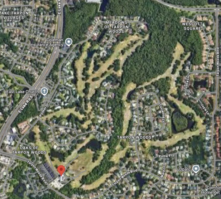
The permit record concerns a proposed mitigation bank in the Tarpon Woods golf-course landscape in unincorporated Pinellas County. The area lies within the Lake Tarpon watershed; Brooker Creek is the lake’s main tributary. Brooker Creek Preserve is a separate County preserve in the broader watershed. Parcel lines, a proposed bank area, wetlands, flood zones, and an eventual conservation-easement footprint are different layers and should not be treated as interchangeable.

Text legend

Parcel
A property-record unit; not necessarily the permit or easement boundary.
Proposed bank area
An applicant-defined review area that may change before any decision.
Flood map
Regulatory or planning information; not a prediction of every flood.
Watershed
Land draining toward a water body; not a property boundary.
Preserve
County-managed conservation land; not evidence that adjacent private land is within the preserve.
Historic primary-source trail

1847, 1944, and 1970 map evidence

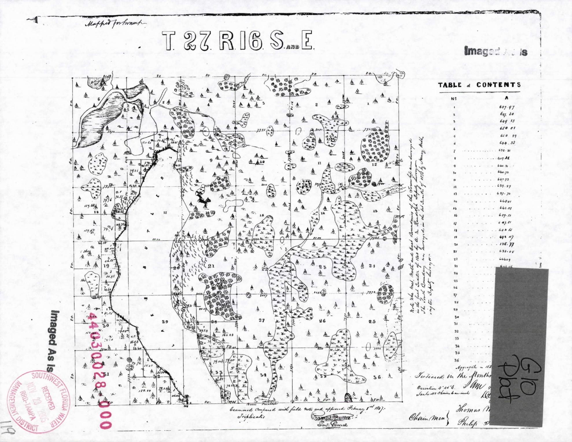
Michelle Hollidge’s August 26, 2026 public filing identified historic exhibits in SWFWMD’s older Tarpon Woods Drainage Improvements record. We confirmed the three exhibits at pages 65–67 of the official 2005 Application 57947 / ERP 30028.000 package.

See the maps and analysis
1847 General Land Office township plat for Township 27 South, Range 16 East
1847 GLO township plat, reproduced at page 67 of the official SWFWMD drainage package.

Federal cadastral survey

Orientation: Tarpon Woods is associated with Section 34, Township 27 South, Range 16 East, along the bottom row of the plat.

Use: Compare the original symbols and field notes with the applicant’s claimed historic ecological baseline.

Limit: Cadastral plats were made to survey public lands. Their symbols are not a current wetland delineation or a modern habitat map.

Search BLM GLO records
The necessary overlay

The record now contains at least six distinct geographic concepts that must not be blurred together:

  • the 172.46-acre applicant-proposed bank area;
  • the surveyed parcels and legal descriptions;
  • existing wetlands and surface waters;
  • FEMA flood zones and the regulatory floodway;
  • historic features depicted in the 1847 plat, early aerials, and federal quadrangles; and
  • each proposed restoration, enhancement, creation, preservation, upland-credit, earthwork, planting, and conservation-easement area.

Our position is that SWFWMD should require one signed, sealed, georeferenced exhibit showing every layer, acreage, overlap, and exclusion. That is the only defensible way to test whether existing wetlands, floodway land, or already-functioning habitat are being mislabeled or over-credited.

Open the official 2005 source package
Current regulatory layer

Brooker Creek regulatory floodway crosses the landscape

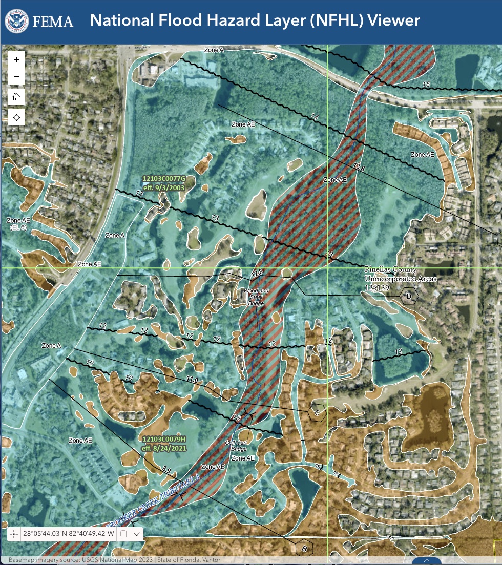
The FEMA National Flood Hazard Layer view captured August 28, 2026 shows the regulatory floodway as the red-and-green hatched corridor through the broader Tarpon Woods area. Zone AE extends beyond that corridor. Visible map annotations include panel 12103C0077G, effective September 3, 2003, and panel 12103C0079H, effective August 24, 2021.

Read the permit-review case study
FEMA National Flood Hazard Layer viewer showing the hatched regulatory floodway following Brooker Creek through the broader Tarpon Woods area
FEMA NFHL Viewer capture supplied by William Nobles, August 28, 2026. FEMA’s live viewer, effective products, and legend control.

What this image does—and does not—show

The hatching is not decoration: it identifies the regulatory floodway shown by FEMA’s layer. It makes floodway overlap a question that should be answered on the applicant’s signed-and-sealed plans, not left to inference from separate exhibits.

Campaign position: the mapped floodway should remain untouched unless the applicant proves through every applicable County, FEMA, and District process that each proposed activity is lawful and produces no adverse hydraulic effect.

Important limit: this screenshot is an orientation image, not a survey, property-specific determination, permit decision, or substitute for FEMA’s effective FIRM and Flood Insurance Study. Do not use the screen image to measure an acreage or locate a legal boundary.

Authoritative map panels

Each panel provides a source, access date, orientation, and a plain-language limitation. No third-party map tiles are copied or embedded.

Parcels and property records

Pinellas County enterprise GIS

Orientation: Search the Tarpon Woods golf-course area, then inspect parcel and property-appraiser layers in the official viewer.

Legend: County viewer symbology controls; consult its layer list and metadata.

Limit: Displayed parcel geometry is informational. Confirm ownership, legal descriptions, and current records with the responsible County offices.

Source: Pinellas County · accessed August 19, 2026

Open County GIS applications
Land use and zoning

County zoning and future-land-use data

Orientation: Review the relevant County layers separately from parcel ownership and the SWFWMD permit record.

Legend: Use the official layer definitions and effective dates.

Limit: A mapped designation alone does not establish legal title, a surveyed boundary, a permit approval, or the lawfulness of a separate future proposal.

Source: Pinellas County · accessed August 19, 2026

Open zoning and land-use data
Regulatory flood information

FEMA Flood Map Service Center

Orientation: Search the broader Tarpon Woods area in FEMA’s official service and inspect the effective product and panel date.

Legend: FEMA zone and floodway definitions control.

Limit: Being inside or outside a mapped zone does not mean a place will or will not flood. Use an official determination for legal or insurance decisions.

Source: FEMA · accessed August 19, 2026

Open FEMA map service
Local flood information

Pinellas County flood maps and zones

Orientation: Use the County page for evacuation-zone, flood-zone, and local assistance links; those layers answer different questions.

Legend: Follow the County’s definitions for each product.

Limit: An evacuation zone is not the same as a FEMA flood zone, and neither substitutes for project drainage modeling.

Source: Pinellas County · accessed August 19, 2026

Open County flood maps
Watershed

Lake Tarpon SWIM Plan

Orientation: The plan maps the regional Lake Tarpon watershed and describes Brooker Creek as its main tributary.

Legend: Use the plan’s figure titles, notes, and scale.

Limit: Watershed context does not determine parcel boundaries or prove project-specific flood effects.

Source: SWFWMD, 2025 plan · accessed August 19, 2026

Open the SWIM Plan
Conservation land

Brooker Creek Preserve

Orientation: The County page describes the preserve and provides official visitor and management context.

Legend: Follow County maps and posted boundaries.

Limit: The proposed bank is not represented here as part of Brooker Creek Preserve. Any expansion would require separate ownership, funding, and County action.

Source: Pinellas County · accessed August 19, 2026

Open preserve information
Current proposed bank

Application 930235 / ERP 47575.002

Orientation: The applicant filing describes a proposed 172.46-acre bank area. Consult the current record’s plan sheets for the applicant’s submitted geometry.

Legend: Applicant plan labels and revisions control for what was submitted.

Limit: This is an applicant-proposed review boundary, not a surveyed public-access map, final permit boundary, or recorded conservation easement. It may change during review.

Source: applicant filing in SWFWMD record · accessed August 19, 2026

Open current official record
Withdrawn earlier application

Application 889588 / ERP 47575.000

Orientation: Use this record only to understand the earlier conceptual application and its historical plan materials.

Legend: Historical applicant plan labels apply only to that submission.

Limit: The application was withdrawn effective December 6, 2024. Its geometry is not the current application boundary.

Source: SWFWMD historical record · accessed August 19, 2026

Open withdrawn record
Historic drainage record

Application 57947 / ERP 30028.000

Orientation: The 2005 Tarpon Woods Drainage Improvements package includes the historic map exhibits at PDF pages 65–67.

Legend: Consult each underlying federal map’s original legend and field notes. Handwritten labels in the package are later annotations.

Limit: An exhibit’s presence in an official permit file proves what was filed, not that SWFWMD adopted every annotation or interpretation.

Source: SWFWMD historical record · checked August 28, 2026

Open official record
County and SWFWMD flood analysis

2010 Brooker Creek Alternative BMP Analysis

Orientation: The complete 398-page package documents the watershed model, coordination with the Tarpon Woods Action Committee, and Tampa Bay Engineering’s September 2007 Tarpon Woods flood-protection presentation.

Legend: Use the report’s modeled alternatives, assumptions, node tables, maps, and limitations—not an isolated sentence or slide.

Limit: The study is strong historic drainage evidence, but it predates the current bank design and does not substitute for current project-specific modeling.

Source: Pinellas County / SWFWMD / URS, May 25, 2010 · checked August 28, 2026

Safe field use

  • Use public roads, public records, or your own property.
  • Do not trespass to “verify” a line or feature.
  • Do not publish precise wildlife, nest, burrow, home, or resident coordinates.
  • Keep screenshots with their source URL, access date, layer names, legend, and scale.

Need a legal or technical boundary?

A surveyor, title professional, floodplain administrator, or responsible agency may be needed depending on the question. This page is an evidence-navigation aid, not a substitute for those records or services.